In the quarter century since the late Rob Harvey founded Yukon Engineering Services (YES), the company has had its hand in the majority of mining venture in Yukon and northern B.C.
It’s not hard to see why.
With expertise in everything from designing tailings and water dams, to conducting site surveys and mapping, ore body geometry modelling and open pit mine design, the company has many of the technical angles of the mining industry covered.
YES also has a proven track record in road location and design, heap leach (a process used to extract minerals from ore), construction management, site servicing and settling pond design.
Christine Doke is the company’s managing principal and chief financial officer. She easily lists of some of the larger YES projects.
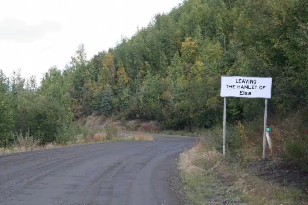
“We worked at Faro for both its operation and reclamations phases. We conducted surveying for Howard’s Pass. We designed the haul road for the Elsa/Keno project to make sure it bypassed the hamlet of Keno, and we completed the civil engineering design for Wolverine.”
Handling such a diverse portfolio requires a rounded team that includes civil engineers, surveyors, technicians, computer-aided design and drafting (CADD) technologist, project managers and designers.
This range of expertise has allowed YES to expand to provide the majority of the private sector engineering, surveying and CADD services in Yukon.
YES also provides support to aerial and satellite mapping companies from down south Doke explains.
“We offer ground truthing [collecting data in the field in order to relate image data to real features and materials on the ground], feature mapping and target layout to help orthorectify the aerial images to the centimetre accuracy level [geometrically correcting images for things such as topographic relief, lens distortion, and camera tilt so that the scale is uniform, resulting in an image with the same lack of distortion as a map].”
Aerial mapping can be difficult in Yukon’s remote areas, Doke admits.
“Weather delays due to rain, wind and cloud cover can cause unforeseen delays that last for days. The decision to fly the aerial mapping lies with the southern companies who depend on the same weather forecasts that we get, which can be unreliable at best,” she says.
Weather isn’t the only factor that can prove challenging, however.
“One of our biggest concerns is having coordinated control targets on the ground destroyed by bears, moose and other curious critters prior to aerial photographs being taken. We try to mitigate this through the use of bear spray on the cloth targets and have had good success so far.”
Doke explains the industry standard is now to utilize the nation-wide NAD83 coordinate system, which stands for North American Datum of 1983. This makes it possible to integrate various data sets seamlessly.
“Surveying and mapping information is now complementing other uses of data in developing and understanding our natural environment and providing industry information that allows them to plan for future development in a sustainable manner.”
Operating in the territory also requires a diverse range of stakeholders to work together.
“The nature of the working environment in the Yukon requires a constructive and positive attitude between stakeholders and other consultants working on the same project,” Doke says.
“Many of YES’ projects have required working in conjunction with construction companies, territorial and federal government organizations, utilities providers, mine developers, municipal councils, various local and outside consulting companies as well as various First Nations.
“The complexity of many projects taking place in the Yukon now requires complementary skill sets and understanding of local challenges and specificities.”
Doke is quick to stress the benefits of working in the territory.
“One of the greatest rewards working in this jurisdiction is its relatively small size and population. As a community champion, you are able to see first-hand the benefits in giving back to the community.”
While Doke admits obtaining the proper resources in the territory can be a challenge, “when we all work together and provide training to our residents and First Nations people, the territory continues to strengthen both socially and economically.”
Amber Church is a painter, writer and sports enthusiast. You can reach her at [email protected].